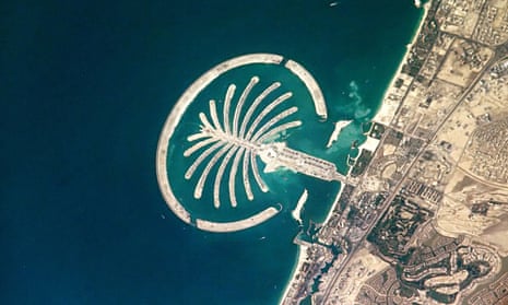
This image is a day-time photograph of Palm Jumeirah taken by NASA Commander Leroy Chiao from aboard the International Space Station in 2005. Jumeirah was the first of a series of new islands off the coast of Dubai designed to add hundreds of kilometres of private coastline to the city.
The islands were developed through a process of dredging sand from the floor of the Persian Gulf and spraying it to form shaped land masses. This photo was taken as work on the land mass itself was being completed and in advance of the start of construction of villas and hotels that would house 65,000 people. It was featured in various newspapers and websites shortly after it was taken.
What only becomes obvious from the heightened perspective is that the island is constructed in the shape of a palm tree (the crescent around the perimeter serves as a barrier). The spacebourne vantage point reveals the landscape in both the pictorial and geographic senses. Palm Jumeirah’s positioning, of course, enacts a rather simple visual pun in which the palm tree pretends to grow out of Dubai’s main coastline.
For Dubai’s real estate holding corporation, Nakheel Properties, this distinct shape, which they claimed in their marketing campaigns is visible from the moon (which is difficult to confirm), was a key selling point. It is difficult to tease out how substantial of a role it played in the pricing of villas and other properties on Jumeirah prior to the onset of Dubai’s 2009 crisis. However, it is clear that the island’s value as real estate and elite socio-economic status are intertwined with its qualities as a picture.
But why was this transformation of land into symbols visible from space, but for the most part only accessible to the majority of us non-astronauts via photographs, so resonant? A landscape intervention at this scale is remarkable in and of itself, but beyond this, it signifies a breakdown in cultural distinctions between land and media.
The shaping of the island itself was aided by the passage of signals between the boats that sprayed the sand and the global network of GPS satellites that provided location data to the required precision. The island is dotted with mobile phone masts that are designed to appear as palm trees. While these kinds of examples are by no means unique to Palm Jumeirah, the shape of the island seems to amplify their significance to contemporary and future changes in the built environment.
Ben Campkin is the author of Remaking London: Decline and Regeneration in Urban Culture (IB Tauris, 2013), director of UCL’s Urban Laboratory, senior lecturer in the Bartlett School of Architecture and co-editor of Urban Pamphleteer.
Mariana Mogilevich is a historian of architecture and urbanism and Mellon Fellow in architecture, urbanism and the humanities at Princeton University.
Rebecca Ross is a graphic and interaction designer and urban historian, senior lecturer at Central Saint Martins School of Art and Design and co-editor of Urban Pamphleteer.
Find out more about the project at Picturing Place and on Twitter #picturingplace.

Comments (…)
Sign in or create your Guardian account to join the discussion