YONAGUNI MONUMENT ( submerged site in Japan), also known as YONAGUNI (Island) SUBMARINE RUINS, refers to one of the largest features within a submerged rock formation off the coast of YONAGUNI, the southernmost of the RYUKYU Islands in Japan.
Masaaki Kimura. Professor Emeritus from the Faculty of Science at the University of the Ryukyu claim that the formations are man-made stepped monoliths. His ideas are disputed and there is debate about whether the site is completely natural, a natural site that has been modified or a man-made artefact.
The sea of YONAGUNI is a popular diving location during the winter months, due to its large population of hammerhead sharks. In `1987, while looking for a good place to observe the sharks, Kihachiro Aratake, a Director of the YONAGUNI – CHO Tourism Association, noticed some singular seabed formations resembling Architectonic Structures. Shortly thereafter, a group of scientists, directed by Masaaki Kimura, visited the formations.
The formation has since become a relatively popular attraction for divers and instructors, despite the strong currents. In 1997, Japanese Industrialist, YASUO WATANABE sponsored an informal expedition comprising writers John Anthony West and Graham Hancock, photographer Santa Faiia, geologist Robert Schoch, a few sport divers and instructors and a film crew for Channel – 4 and Discovery Channel. Another notable visitor was free diver Jacques Mayol, who wrote a book on his dives at YONAGUNI.
The Monument consists of medium to very fine sandstones and mudstones of the Lower Miocene Yaeyama Group believed to have been deposited about 20million years ago. Most of the formations are connected to the underlying “rock mass” as opposed to being assembled out of free-standing rocks.
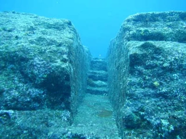
The main feature (the Monument Proper) is a rectangular formation measuring about 490 x 130ft, and about 90ft tall, and the top is about 16ft below sea level. Some of its details are said to be :
* 2 closely-spaced pillars which rise to within 8ft of the surface.
* A 16ft-wide ledge that encircles the base of the formation on 3 sides.
* A stone column about 23ft tall.
* A straight wall, 33ft long.
* An isolated boulder resting on a low platform.
* A low star-shaped platform.
* A triangular depression with 2 large holes at its edge.
* A L-shaped rock.
YONAGUNI lies in as earthquake-prone region and such earthquakes tend to fracture the rocks in a regular manner. On the northeast coast of YONAGUNI, there are regular formations, similar to those seen at the Monument. John Anthony West suggests the “walls” are simply natural horizontal platforms that fell into a vertical position, when rock below them eroded and the alleged roads are simply channels in the rock.
The existence of an ancient stone-working tradition at YONAGUNI & other RYUKYU Islands is demonstrated by some old tombs, and several stone vessels of uncertain age. Small camps, pottery, stone tools and large fireplaces, were found on YONAGUNI, possibly dating back to 250 BCE. However, Archaeologist Richard J. Pearson notes that these were small communities, adding, “They are not likely to have had extra energy for building stone monuments.
The flat parallel faces, sharp edges and mostly right-angles of the formation have led some to conclude that the features are man-made. These features include a “trench”, that has two internal 90degree angles, as well as the twin megaliths that, according to Kimura, appear to have been placed there. These megaliths have straight edges and square corners, however, sea currents have been known to move large rocks on a regular basis. Some of those who see the formations as being largely natural, claim that they may have been modified by human hands.
Other evidence, presented by those who favour an artificial origin, include the two round holes (about 2ft wide) on the edge of the Triangle Pool feature, and a straight row of smaller holes that have been interpreted as an abandoned attempt to split off a section of the rock by means of wedges, found in ancient quarries. Kimura believes, he had identified traces of animal drawing and people engraved into the rocks, including a “horse-like” sign, he believes resembles a character from the KAIDA SCRIPT. Some have also interpreted a formation, on the side of one of the monuments, as a crude mole-like face.

Kimura first estimated that the monument must be at least 8,000BCE, dating it to a period when it would have been “above water”. In a report given to the Pacific Science Congress in 2007, he revised the estimate to 2,000 or 3,000 years ago, because the sea level then was close to current levels. He suggests, that after construction, Tectonic Activity caused it to be submerged below sea level. He believes he can identify a pyramid, castles, roads, monuments and a stadium. Kimura also surmised that the site may be a remnant of the MYTHICAL LOST CONTINENT of MU.


Pingback: Yonaguni monument | oshriradhekrishnabole
That’s an amazing underwater monument.