Disclaimer
This entry contains information known to us from a variety of sources but may not include all the information currently available. Please be in touch if you notice any inadvertent mistakes in our presentation or have additional knowledge or sources to share. Thank you.
Archive
Le Main du Juif, Algeria
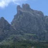
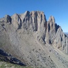
La Main du Juif, which means "The Hand of the Jew," is one of the peaks of the mountain range at Djurdjura. It is "situated, as the crow flies, 3 km west of Tizi N'Kouial. The village of Timerass is two kilometers further north on the way down the summit." It has the appearance of a six fingered hand, and its name is derived from the legend that Jews once prayed on the mountain's ridge [1]. La Main du Juif is climbable, as evidenced by Claude Grandjaque's exploits [2].
Description
Le Main du Juif is located in the Djurdjura Mountains (also known as Great Kabylie or Grande Kabylie). Great Kabylie is a mountain chain which runs east-to-west for about 25 miles in two lines of peaks. The mountains are located east of the Isser River and northwest of the Wasi Soummam, and are also a part of the Djurdjura National Park and Akfadou National Reserve. The tallest mountains in the chain are Lalla Khedidja (standing at 7,572 feet tall), Akouker (7,562 feet), and Heïdzer (7,100 feet). Although the landscape along the mountain chain is quite harsh, the Djurdjura mountains support a variety of wildlife and highly populated villages. Indeed, the villages in the Djurdjura mountains, which exist along the eastern slopes of the mountain chain and within the Sebaou and Soummam valleys, exist on subsistence cultivation and in deep poverty. As such, much of the population in the Djurdjura mountains has migrated to France or other cities in Algeria. The region surrounding the Djurdjura mountains is well known for its handicrafts, as well as its distinctively Berber culture. In fact, the villages of the Djurdjura mountains enjoyed great security from the mountain range, and were never fully controlled by the Romans, Arabs, Turks, or French [3].
Sources
[1] Encyclopædia Britannica Online, s. v. "Kabylie," accessed June 25, 2014, http://www.britannica.com/EBchecked/topic/309347/Kabylie.
[2] Claude Grandjaque, "Les Voies Dans La Main Du Juif," La Voie Chérif, N.p., April 17, 2011, Web, accessed June 16, 2014, http://lavoiecherif.miages-djebels.org/spip.php?article1.
[3] Encyclopædia Britannica Online, s. v. "Kabylie," accessed June 25, 2014, http://www.britannica.com/EBchecked/topic/309347/Kabylie.
Photos
Mca, Yelles. "Gros plan sur la Main du Juif." Panoramio. May 9, 2011. Accessed June 30, 2014, http://mw2.google.com/mw-panoramio/photos/medium/52401293.jpg.
Kerkar, Adlen. "La main du juif Tikjda." Panoramio. October 23, 20087. Accessed June 30, 2014, http://static.panoramio.com/photos/large/5501019.jpg.